-
Legend Information:
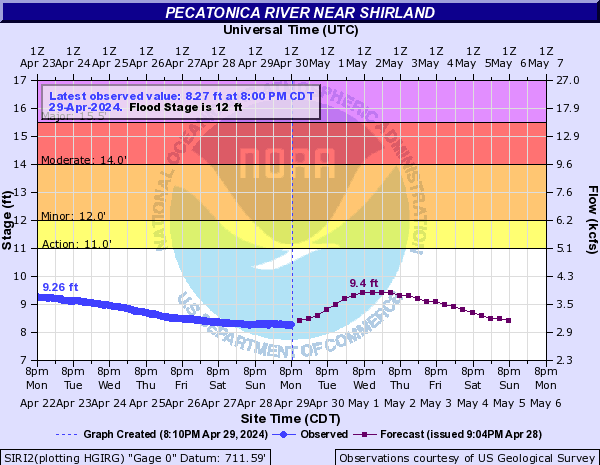
Pecatonica River near Shirland. This gauge is not effect by the actions Fordam Dam. This section of the river is free flowing.
NWS Rockton Gauge. This gauge is not effect by the actions Fordam Dam. This section of the river is free flowing.
NWS Gauge at Latham St Bridge. Gauge that give water level in upper pool. Gauge used by many public agency to determine when the river is closed for use by public. 8 ft is the “No Wake” mark and 10 ft is the River “Closed” mark as shown on the graphs.
NWS Gauge at Auburn St Bridge Gauge that gives water levels downtown. If you subtract flow rate at Auburn Gauge from Latham Gauge you will get an idea how much water is going thru the gates.
NWS Gauge at Rockford Dam Gauge that gives water levels at the Dam. Permit requires the dam to maintain a height of 2.5 feet. This chart was made available via private funds from the RRHA “River Gauges Fund”.
Try www.rockriverhomeowners.org/mobile.htm for a mobile device friendly river height page.
River heights shown below give a quick overview of water levels on the Rockford area.
For more detail information and how to read the gauges follow the links to the National Weather Service website gauge


Rock River Heights